THE NORTH WALES COAST
RAILWAY: ROUTE GUIDE
Rheilffordd arfordir gogledd Cymru
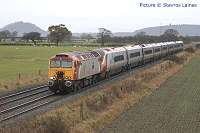
CREWE to HOLYHEAD
THE CONWY VALLEY
THE CONWY VALLEY LINE
Original text by Dave Sallery
The 28 miles (45 km) of single-track railway linking the main line at Llandudno Junction to Blaenau Ffestiniog offers some of the most picturesque and spectacular scenery anywhere in Britain.
Our train, which has probably come from
Llandudno, leaves the main
line
just outside Llandudno Junction station. On the right can
be seen the rail freight terminal, opened in 1980, and still
theoretically available for use, although it unfortunately has
seen no rail traffic since 1999.
We pass under the A55 road, and the area of marshland on our right is a
bird
sanctuary owned by the Royal Society
for the Protection of Birds and
open
to the public. The sanctuary is built on land which was reclaimed
following
the construction of the Conwy road tunnel.
Soon we are presented with a very fine view of the Conwy Estuary at its widest point. Conwy Castle, with its attendant bridges and town walls, is clearly seen, as is the embankment carrying the former main road and railway. We soon arrive at our first stop - Glan Conwy (1 mile 39 chains from Llandudno Jc.) Like all the stations on the branch this is unstaffed, tickets being taken and issued by the conductor-guard. Another point of interest is the set of wooden steps to assist passengers in and out of the train. This station, and also the one at Dolgarrog, were closed under the Beeching Plan of the 1960s, but re-opened a few years later. At low tide, the marshes here, and indeed the whole length of the tidal River Conwy, is a paradise for bird-watchers - grey heron, mallard, shelduck, curlews and oyster-catchers, to name but a few, are clearly visible.
Leaving Glan Conwy behind, the estuary now begins to narrow. We continue south,following the river's every turn, with the hills and mountains becoming noticeably closer. The mountains to our right are known as the Carneddau and form the largest area over 3000 feet south of the Scottish Highlands. Hidden among the trees to our left are the celebrated Bodnant Garden, owned by the National Trust, and well worth a visit. A particularly good time to visit is in the spring when the famed Laburnum Arch is in full bloom.
Our next stopping point, and the nearest
station to Bodnant Garden for those who enjoy an uphill walk, is Tal-y-Cafn
(5
m 5 ch.) The road
bridge
over the Conwy here replaced a ferry crossing, which had existed since
Roman times. A member of Network Rail staff is based here to
operate the level crossing, and the station has been adopted by members
of the Llandudno and Conwy Valley Railway Society who maintain a garden
on the disused second platform and have erect an old-fashioned station
nameboard.
Shortly after leaving Tal-y-Cafn, the
ancient church of Caerhun is seen
on the opposite bank, surrounded by ancient yew trees. Nearby are the
remains
of the Roman settlement of Canovium. If you follow the lines of pylons
to the skyline on the right you will see the historic pass of Bwlch
Ddeufaen.
This was the route of the Roman road from Canovium to Segontium
(Caernarfon).
It was also a stage-coach route from Anglesey and Ireland, before the
coastal
route via Penmaenmawr was built.
Continuing in close proximity to the
river,
the nearest conical
peak,
on our right, is Pen-y-Gaer, site of a well-preserved Iron Age
hill-fort.
Our next calling-point is Dolgarrog (8 m. 12 ch). This village
leapt
to prominence in 1925, when a dam, supplying water to the hydroelectric
power plant at the Aluminium works, gave way. The ensuing flood caused
sixteen deaths. and many injuries. The gash in the old un-repaired dam
walls
is still visible high up in the hills as a sombre reminder.
The bridge
over the river originally carried a siding to the aluminium works,
although rail traffic ceased many years ago; the works itself, which
was the a major employer in the area, closed in 2007 and has since been
demolished. In 2013 plans
were announced to develop a 'surfing and water sports park' on the
site. The bridge remains available to pedestrians, and the Dolgarrog
Railway Society is developing a heritage railway operation based around
the former works sidings.
We continue up the slowly narrowing valley along a section very liable to flooding in winter, the boulders along the side of the line being placed there in order to prevent the track being swept away as has happened quite frequently in the past.
We are now at the limit of the tidal Conwy, and the long straggling village across the river is Trefriw, which was formerly served by pleasure steamers from Conwy . This village is well known for its woollen-mill, and its chalybeate mineral-water springs, reputedly of medicinal value.
Our arrival at the town of Llanrwst is
marked by the
crossing loop which comes
just
before the rather imposing but derelict Llanrwst North station
(11m
17 ch.) This is the only passing loop on the branch; the service
is worked by just one train, but when excursion trains use the line,
there may be another train awaiting our arrival. The
interested
observer may watch the exchange of metal tokens between our driver and
the signalman. This process ensures complete safety in the working of
trains
on a single-track railway.
After a short run we arrive at the new Llanrwst
station (11m 57 ch.) opened on 29 July 1989 as an act of
faith
in the future of the line. This station is far closer to the centre of
the town. Llanrwst is a pleasant little Welsh market town and has a
splendid
road bridge over the Conwy, built by Inigo Jones in 1636, and still
in
use today. Nearby is Gwydr
Castle, a house built in Tudor times and once famed for its
peacocks, which offers bed and breakfast accommodation
Leaving Llanrwst, the heavily-forested
hill to
our right was once a
major centre for lead-mining. However, since those days, much
reclamation
has taken place, and there are some delightful signposted walks and
mountain
bike trails to be enjoyed. We now cross the River Conwy on a steel
girder
bridge, and enter the Snowdonia National Park. Very shortly we arrive
in Betws-y-Coed (15
m. 2 ch.) Although only a small village, it stands at the
meeting-point
of three rivers: the Lledr, which we will follow for the next part of
our
journey; the Llugwy, which flows down from Capel Curig and drains a
large
part of the Glyder and Carneddau ranges and, of course, the Conwy.
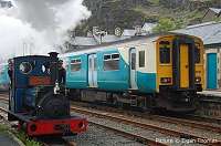
Betws-y-Coed has much to interest the casual visitor, and it is a major centre for the tourist industry. At the station itself, a particular attraction is the Conwy Valley Railway Museum, and miniature trains may frequently be seen running alongside their larger counterparts. At the Stablau Visitor Centre, near the station can be found details of guided walks starting from stations along the line and other attractions. Betws is also a starting-point for the Snowdon Sherpa bus service for spectacular trips around Snowdonia. Details of the Snowdon Sherpa network may be found in the railway timetable booklet for North Wales.
The next part of our journey is what really makes this railway line something special. Thus far, our journey has been along a pleasant pastoral river valley. However, we are about to enter the very heart of the Welsh Mountains. Although the line to Llanrwst was opened in 1863, and to Betws-y-Coed in 1868, a further eleven years elapsed before the first train steamed triumphantly into Blaenau Ffestiniog, on 22 July 1879. Indeed, at one time the London & North Western Railway seriously considered building the line to the narrow gauge of 1 foot 11½ inches, the same as the Ffestiniog Railway, because of the difficult terrain. Victorian fortitude prevailed, however, and one can readily appreciate from the train how steep and sinuous is the course eventually chosen.
Leaving Betws-y-Coed station, look out for the bridge on our left. This carries the main A5 London-Holyhead road, engineered by Thomas Telford, and the arch of the bridge has an inscription that it was built in the same year in which the Battle of Waterloo was fought, 1815. Following a short spell in dense conifer forest, Beaver Pool Tunnel is followed by the stretch of water of that name. This can be glimpsed through the trees down to our left. This marks the confluence of the rivers Conwy and Lledr, our course following the latter. The upper stretch of the Conwy from this point is known as the 'Fairy Glen', and is a spectacular stretch of rocky pools and surging cataracts. A recent addition in the Fairy Glen is that of a fish ladder to enable salmon to colonise the upper reaches of the Conwy.
The harsher engine noise of our train
gives a
hint of the severe
gradients
which we now encounter as we continue up the narrow, thickly wooded
valleys.
A temporary respite for the firemen of steam trains was provided by
Gethins
Bridge. This is a handsome, stone-built viaduct of seven arches,
carrying
us across the river and the main road. Waterfalls and rock
pools
abound in the river, now well below us on the right and we soon enter
the
short, unlined rock tunnel emerging at Pont-y-Pant station (19
m
29 ch.) Despite the apparent lack of houses, Lledr House, a family-run
independent hostel which was owned by the Youth Hostels Association
until 2001, is nearby and contributes considerably to the passenger
revenue. The spectacular
waterfall
on the River Lledr is well worth a visit. Another
short
tunnel brings railway and river together again.
A more gentle stretch
of
track follows past the water-meadows, and through another short tunnel
to Dolwyddelan (20 m 62 ch.) The impressive peak rearing
majestically
to our right is Moel Siabod, at 2861 feet. Disused slate quarries are
observed
on both sides, this being at the northern limit of the Blaenau slate
measures.
Dolwyddelan is a picturesque peaceful village, and excellent
rock-climbing
and walking is available in the vicinity.The station is cared for by a
local group whose plant displays have won awards.
Leaving this station, to the right is the stark, square tower which is all that remains of the once-proud Dolwyddelan Castle. This was built by the native Welsh Prince Iorwerth in the twelfth century and was the birthplace of Prince Llewelyn the Great, his son. Prince Llewellyn is commemorated in the name of Carnedd Llewellyn, one of the highest Welsh peaks. The castle is steeped in Welsh mythology, and is open for visiting courtesy of Cadw. Continuing up the valley, through the short Bertheos Tunnel and under the new road bridge, Snowdon and its attendant peaks may be seen above the open moorland directly ahead. We have now parted company with the main road, which climbs steeply up to the Crimea Pass, named after a public house which formerly stood at its summit. This road is often blocked by snow in winter.
The charmingly named, and situated, Roman Bridge (22m 48 ch.) is followed by a further short tunnel. There is sadly no evidence that the Romans ever built a bridge here. We continue up the narrowing rocky valley, the wheel flanges of our train squealing on the incessant curvature as the train tries to seek out the most level path for our progress. A lonely final stretch, with nothing but sheep for company, leads us to the north portal of the celebrated Ffestiniog Tunnel. This, at 3,726 yards, is the longest single-track tunnel, and the eighth longest tunnel overall, in Britain. Apart from a short curve at the north end, the tunnel is perfectly straight. Construction of this tunnel took four years of hard toil, amid flooding, rock-falls, and explosions. The extremely hard rock required special drills and consequently the tunnel needs no lining. The summit-level of the line at 790 feet, is in the middle of the tunnel, and after what always seems an age in the darkness, we suddenly burst into the open to be confronted by an astonishing vista.
Few towns in Britain can have so
spectacular
or intimidating an
entrance
as Blaenau Ffestiniog, with
vast heaps of slate waste towering
precariously
above and around us, and all in the shadow of lofty mountain peaks. The
slate waste to the right forms part of what were formerly the Oakley
slate
quarries. This was until recently a tourist attraction known as Gloddfa
Ganol but nowadays the complex is owned by Macalpines and is not open
to
the public. It was once the largest slate-mine in the world and had
twenty-six
floors. The vertical difference in the quarry was 1,400 feet and it was
served by 50 miles of underground railways. Because slate extraction
often
produces up to 90% of waste material to 10% usable product, the size of
the waste heaps gives an indication of the frantic activity which
occurred
during the boom years. The quarries to our left form part of the
Llechwedd
complex, now home to the world-famous Miners' Tramway. We now pass
under
the remains of Glan-y-don viaduct. This once supported a spindly wooden
trestle
carrying two-foot gauge slate vehicles. A short distance further on the
right
there used to stand the Baltic Hotel and a row of terraced houses, the
rapacious desire of the Oakley quarry owners for more tipping space
however
led to their evacuation and subsequent burying.
With the Afon Goedol, which flows into
Cardigan Bay, on our right,
we
soon pass the carriage sheds of the Ffestiniog Railway at Glan-y-Don.
The abandoned platform and building of Blaenau Ffestiniog North station
follows shortly after, this was closed in 1982 when the new station was
opened. The goods yard area on the left was once a mass of sidings
where
the slate was transhipped from narrow to standard gauge wagons.
Shortly afterwards, as we near the terminus, the Ffestiniog Railway itself trails in from Porthmadog and parallels us for the short distance to Blaenau Ffestiniog Central Station (27m 40 ch.) This station was newly opened in 1982, following the reopening throughout of the Ffestiniog Railway. The station is built on the site of the Great Western station of the same name which closed in 1961. We have now reached the end of the line although the route continues for a further 5 miles to Trawsfynydd nuclear power station. This section is now disused following the decommissioning of the power station, but until the 1990s there was a regular traffic in nuclear waste to Sellafield from Trawsfynydd. Originally this line continued as far as Bala, where connection was made with the also now-closed Ruabon - Barmouth line.
The delights of Blaenau Ffestiniog and its surroundings are many in number. The slate-mines, walking, rock-climbing, and views are unsurpassed, and the little-changed streets of the town itself give ample cause to remember a time when it was the slate capital of the world.
Last updated April 2014.