THE NORTH WALES COAST RAILWAY: ROUTE GUIDE

Rheilffordd arfordir gogledd Cymru

Select a section for a Virtual Journey:
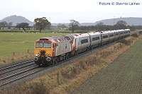
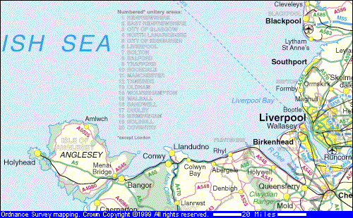

CREWE to HOLYHEAD


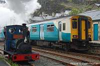
THE CONWY VALLEY - LLANDUDNO JUNCTION TO BLAENAU FFESTINIOG
by Dave Sallery
Rail Traveller's guide to North Wales

Map

Image produced from the Ordnance Survey Get-a-map service. Image reproduced with kind permission of Ordnance Survey and Ordnance Survey of Northern Ireland.


Mileage tables
North Wales main line | Branches | Cambrian Coast line

For train-timers, numerologists and people who just like to know where they are, the following tables the official position of significant points on the North Wales routes. The distances are measured in traditional units of Miles and Chains (80 chains = 1 mile), measured from London Euston. Tunnel lengths are measured in yards, where 1 chain = 22 yards). On the line itself, there are posts marked with each whole number of miles, and intermediate quarter, half and three-quarter mile markers. Passenger stations open to the public are shown in BOLD CAPITALS, and working signalboxes by bold lowercase. Crewe and Chester are controlled by large computerised 'signalling centres.' The mileage is taken at the mid-point of the platforms, except at termini where the end of track is used. Tunnel mileages are for the end nearest London.


Abbreviations: SB=signal box, GF=ground frame, LC=level crossing [L][R]=to left or right of line.Jc=junction.

NORTH WALES MAIN LINE
 
158.00 CREWE 
159.41 Crewe Steelworks SB [L] 
166.11 Calveley (closed station) 
168.46 Beeston Castle & Tarporley (closed sta.) 
168.60 Beeston Castle SB [R] 
172.72 footpath crossing 
177.52 Christleton Tunnel (160 yards) 
179.11 CHESTER
179.56 Windmill Lane tunnel (104 yds) 
179.67 Northgate Street tunnels (218 yds) 
180.18 Roodee Jc (end of 4-tracks) 
181.09 Saltney Jc [Wrexham line L] 
182.29 Mold Junction
[signalbox abolished 2005]
184.73 Sandycroft [signalbox abolished 2005]
186.77 SHOTTON (Wrexham-Bidston line over) 
188.74 Rockcliffe Hall SB
189.47 Rockcliffe Hall tunnel (99 yards)
190.67 Pentre LC 
191.47 FFLINT
193.51 Bagillt LC 
195.76 Holywell Jc SB [between tracks] 
199.12 Mostyn SB [between tracks] & sidings [R] 
201.76 Talacre SB [R] (disused station & colliery) 
202.65 Tyn-y-Morfa LC 
205.43 PRESTATYN (island platform) 
205.52 Prestatyn SB [L] 
208.74 Rhyl No.1 SB
209.08 RHYL (Rhyl no. 2 SB disused) 
213.29 Abergele SB [in sta. between tracks] 
213.30 ABERGELE & PENSARN
215.74 Llandulas viaduct 
217.09 Lysfaen emergency GF & crossover 
217.32 Penmaenrhos Tunnel (485 yds) 
219.37 COLWYN BAY 
223.12 junction with Conwy Valley branch 
(freight depot [L]) 
223.39 LLANDUDNO JUNCTION
223.55 Llandudno Jc SB [R] Llandudno line [R]
224.11 Conwy Tubular Bridge (149 yds) 
224.40 CONWY
224.44 Conwy Tunnel 
226.42 Penmaenbach Tunnel (718 yds) 
228.30 Moel Llys Tunnel (154 yds) 
228.63 Penmaenmawr SB [L]
228.69 PENMAENMAWR
229.77 Pen-y-Clip avalanche shelter (265 yds)
231.48 LLANFAIRFECHAN
232.39 Glan-y-Mor LC 
233.54 Aber emergency GF & crossover 
234.30 Aber Bull LC 
234.59 Wig Farm LC 
237.26 Llandegai Tunnel (505 yds) 
238.19 Bangor Tunnel (890 yds) 
238.71 BANGOR
239.02 Bangor SB [R] 
239.06 Belmont Tunnel (648 yards) 
240.67 Menai Bridge South Jc[double to single track] 
241.09 Britannia bridge (460 yds) 
(crosses Menai Strait to Anglesey) 
241.57 Menai Bridge North Jc [single to double track] 
242.22 Llanfairpwll crossing SB (not block post)) 
242.29 LLANFAIRPWLL
(or Llanfairpwllgwyngyllgogerychwyrndrobwllllantysiliogogogoch)
243.75 Llanddaniel LC 
245.09 Gaerwen SB (disused station) 
245.15 junction for Amlwch line [R]  (disconnected)
249.65 Bodorgan viaduct 
250.59 Bodorgan No.1 Tunnel (413 yds) 
251.01 Bodorgan No.2 Tunnel (115 yds) 
251.52 BODORGAN
254.27 TY CROES up platform
254.31 Ty Croes LC & SB (not a block post [R]) 
254.34 TY CROES down platform
256.04 RHOSNEIGR
260.07 Valley SB [R] LC (nuclear sdg, [R]) 
260.57 Cleifog Uchaf LC 
(Stanley embankment to Holy Island) 
261.56 Anglesey Aluminium works sdgs [R] 
263.26 Holyhead SB [R] (loco sidings [R]) 
263.52 HOLYHEAD (carriage sidings [L]) 


NORTH WALES COAST BRANCHES
 
Conwy Valley branch

223.12/0.30 Junction with main line
0.56 Glan Conwy LC (AHB)
1.43 GLAN CONWY
5.05 TAL-Y-CAFN
5.09 Tal-y-Cafn LC (hand-worked with stop boards)
8.12 DOLGARROG
9.73 Tyn-Ddol LC
10.31 Tan Lan LC
11.08 Llanrwst SB [R] passing loop
11.17 LLANRWST NORTH
11.50 Llanrwst Tunnel (85 yds)
15.02 BETWS-Y-COED
16.14 Beaverpool Tunnel (110 yds)
19.10 Pont-y-Pant Lower Tunnel (144 yds)
19.29 PONT-Y-PANT
19.56 Pont-y-Pant Upper Tunnel (66 yds)
20.62 DOLWYDDELAN
22.19 Bertheos Tunnel (46 yds)
22.48 ROMAN BRIDGE
22.55 Roman Bridge Tunnel (43 yds)
24.33 Ffestiniog Tunnel (2 miles 333 yds)
26 48 Ffestiniog Tunnel south portal
27.33 Blaenau Ffestiniog GF no. 2 
27.41 BLAENAU FFESTINIOG

Llandudno Branch

233.55/0.03 Llandudno Jc SB [R]
1.01 Deganwy Quay LC
1.16 DEGANWY
1.21 Deganwy SB & LC
2.62 Llandudno up siding GF
3.00 Llandudno Station SB
3.14 LLANDUDNO

Amlwch Branch 

Note: this line is currently (2008) not connected to the main line

245.15/0.00 Junction with main line
0.16 Gaerwen GF
15.51 Shell [Rosgoch] GF
17.37 Railtrack/Associated Octel boundary


CAMBRIAN COAST LINE
* indicates a station stop by request only. Notes: (1) All train working on the Cambrian network, except in the Machynlleth station area, the line to Dovey Junction, which is fully signallled, and shunting moves as required at Tywyn, Barmouth and Porthmadog, is controlled by Radio Electric Token Block from Machynlleth SB. (2) The line has very many user-worked level crossings and footpath level crossings: for simplicity, only the busier road crossings which are either staffed or provided with road traffic signals are listed. (3) Some small 'halts' have been closed: these are not shown as they have few visible remains. (4) Mileages are measured from Whitchurch via the Cambrian Railways line to Welshpool which no longer exists. Kilometre posts are also provided at the lineside for use with the forthcoming ERTMS signalling.
75.04 Machynleth SB [R]
75.11 MACHYNLLETH

79.03 DYFI JUNCTION / CYFFORDD DYFI
for line to Aberystwyth [L]
79.12 Dyfi viaduct (152 yards)
81.11 Frongoch (Aberdyfi No.1) Tunnel (200 yds)
82.07 Morfa Bach (Aberdyfi No.2) Tunnel (219 yds)
83.74 Penhalig (Aberdyfi No.3) Tunnel (191 yds)
84.11 PENHELIG* [R]
84.14 Crag-Y-Don (Abertdyfi No.4)
 Tunnel (533 yds)
85.02 ABERDYFI [R]
88.40 Tywyn GF
88.56 TYWYN (passing loop)
89.09 Sandilands LC
90.38 Dysynni river bridge (114 yards)
91.09 TONFANAU* [L]
94.42 Allens LC
95.18 LLWYNGWRIL* [R]
96.55 Friog avalanche sheter (south end)
97.70 Fairbourne LC
97.72 FAIRBOURNE [L]
99.01 MORFA MAWDDACH* [R]
99.40 Barmouth Viaduct (800 yards)
100.08 Barmouth Tunnel (70 yards)
100.18 Old Chapel viaduct (78 yards)
100.44 Barmouth South LC (traincrew operated)
100.50 BARMOUTH (passing loop)
100.56 Barmouth North GF
102.13 LLANABER* [R]
104.36 TALYBONT* [R]
105.04 Bennar Fawr LC
105.54 Llwyn Cadwgan LC (staffed)
105.50 DYFFRYN ARDUDWY* [R]

107.67 Talwrn Bach LC
107.70 LLANBEDR* [L]
108.28 Pensarn river bridge (104 yards)
108.47 PENSARN* [R]
109.17 LLANDANWG* [L]
110.79 Harlech Morfa LC
111.14 HARLECH (passing loop)
113.54 TYGWYN * [L]
113.54 Tygwyn LC
114.43 TALSARNAU [R]
115.64 LLANDECWYN* [R]
115.76 Traeth Bach Viaduct (148 yards)
116.48 PENRHYNDEUDRAETH [R]
117.58 MINFFORDD [R] (Ffestiniog Railway crosses on bridge)
118.14 Minffordd quarry LC (staffed)
118.77 Traeth Mawr viaduct (106 yards)
119.?   Welsh Highland Railway flat crossing
119.41 Traeth Mawr LC
119.77 PORTHMADOG (passing loop)
120.07 Porthmadog GF
124.48 Merilyn LC (signalled & staffed)
124.55 Maes LC
124.74 CRICCIETH [R]
126.66 Dwyfaur River bridge
129.30 PENYCHAIN* [R]
130.52 Afon Ddu viaduct (33 yards)
130.77 ABERERCH* [R]
130.78 Abererch LC
132.31 Pwllheli Goods LC
132.38 Pwllheli Crossing GF
132.57 Pwllheli West GF (in old SB)
132.70 PWLLHELI [R]
Compiled by Charlie Hulme, 2000. Updated 2008.
Acknowledgements to the Quail Map Company and Michael Oakley.

To the North Wales Coast main page